Updated on May 23, 2014
![]()
![]()
Project
Development of system for satellite monitoring of surface water quality in real-time and early-warning system
INTRODUCTION
• The importance of surface water monitoring:
Every living being on Earth needs water to survive. Water is vital to every aspect of our lives.
In the year 1968 by the Charter of the water of the European Council, on the importance of water to humans, are given the basic settings:
- Without water there is no life. Water is a valuable and necessary for the good of man.
- Good water reserves are not inexhaustible. Therefore, the most important task is to keep it, use sparingly and where it is possible increases.
- Water pollution causes a great damage to man and all living beings.
- Water quality must meet the requirements of human health and the predicted mode of utilization.
- Used water should be returned to watercourses under the condition that they are not burdened with something that would disrupt the use of public and private purposes.
- It is the duty of every person that uses water as a common good.
- Water does not know national boundaries and requires international cooperation.
Why is water quality important?
Our water resources are of major environmental, social and economic value, and if water quality becomes degraded this resource will lose its value. Water quality is important not only to protect public health: water provides ecosystem habitats, is used for farming, fishing and mining, and contributes to recreation and tourism.
If water quality is not maintained, it is not just the environment that will suffer – the commercial and recreational value of our water resources will also diminish.
More specifically, the water may be used by the community for:
- supplying drinking water,
- recreation (swimming, boating),
- irrigating crops and watering stock,
- industrial processes,
- navigation and shipping,
- production of edible fish,
- protection of aquatic ecosystems,
- wildlife habitats,
- scientific study and education.
What affects the quality of our water?
Water quality is closely linked to the surrounding environment and land use. Other than in its vapor form, water is never pure and is affected by community uses such as agriculture, urban and industrial use, and recreation. The modification of natural stream flows by dams and weirs can also affect water quality. The weather, too, can have a major impact on water quality, particularly in a dry country which is periodically affected by droughts.
Monitoring purposes:
Monitoring can be conducted for many purposes. Five major purposes are to:
- characterize waters and identify changes or trends in water quality over time;
- identify specific existing or emerging water quality problems;
- gather information to design specific pollution prevention or remediation programs;
- determine whether program goals — such as compliance with pollution regulations or implementation of effective pollution control actions — are being met; and
- respond to emergencies, such as spills and floods.
PROJECT DESCRIPTION
The main objective of the project is the development of system for satellite monitoring of surface water quality in real-time and early-warning system.
The desired result is to establish a network of sensors to track physico-chemical parameters of surface water via satellite in real-time and early-warning system.
Monitoring results will serve as a starting point for various analyses, modeling and studying the short-and long-term consequences of water pollution, and also as a basis for the development of strategic documents in the field of environmental protection and sustainable development. In addition, this system would be used to monitor the effectiveness of measures taken with the aim of sustainable water management at national and regional level.
• Advantages of monitoring via satellite in relation to the monitoring from the ground;
The fact is that the monitoring of water quality in the world via satellite is not represented and that the use of today’s technology it can certainly be realized. Therefore, the competent office of the UN (UN OOSA) highlighted as a priority to support projects that aim to use satellite technology for this purpose. Given the importance of water resources, a huge need for constant monitoring in the world exists, but when choosing a method it is always raises the question of costs.
Taking into account the topography of the terrain, gathering information from placed sensors from the ground (GSM / GPRS, RF, etc.) as a rule requires the cost of installing additional repeaters or costs of providers with possible limitation of the area covered by the signal, while the use of satellites mentioned problems of additional costs from the start were eliminated, and the surface coverage is incomparably greater considering that the satellite is at an altitude of about 700 km (LEO) and the ‘visibility’ diameter is about 1000 km. In this way, it can be covered and an inaccessible terrain such as river flows between high mountains, etc., which indicates that there is practically no limiting factor. The common for system for monitoring via satellite and the system for monitoring from the ground are maintenance costs. The cost of maintaining the system for monitoring via satellite inputs: control sensors and buoys (at least once a month), than daily control signal and response speed of sensors while reading, when receiving a signal and decoding at the Center for decoding, processing and distribution of satellite data and user interface. While to the cost of maintaining the system for monitoring from the ground on all of the above must be added and the cost of maintenance of repeaters.
Today, thanks to the development of nano-technology, satellites are getting smaller, and therefore the cost of development and launching are a lot more affordable for countries and organizations. Realization of this project achieves two goals. The first is described above (development of system for satellite monitoring of surface water quality in real-time and early-warning system), while the second goal is upgrading of knowledge related to space engineering to knowledge acquired during education process and training to create own satellite/s.
Both goals will be achieved through participation in HUMSAT project which is being implemented through the program of European Space Agency (ESA) and the support of the UN OOSA, whose carrier is the University of Vigo (Spain).
More information’s on HUMSAT can be found at the following addresses:
————–http://www.esa.int/Education/Background_on_HumSAT
————–http://www.humsat.org/
————–https://directory.eoportal.org/web/eoportal/satellite-missions/h/humsat
Given that freshwater resources are vital and that there is a danger of jeopardizing this vital resource reality, it is our duty and obligation to knowledge and technology we use to solve, not to create problems in order not to come in a hopeless situation, but to us and our descendants ensure the future.
• About the system:
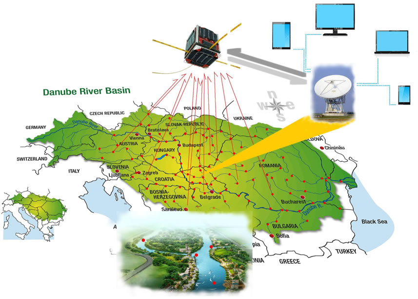
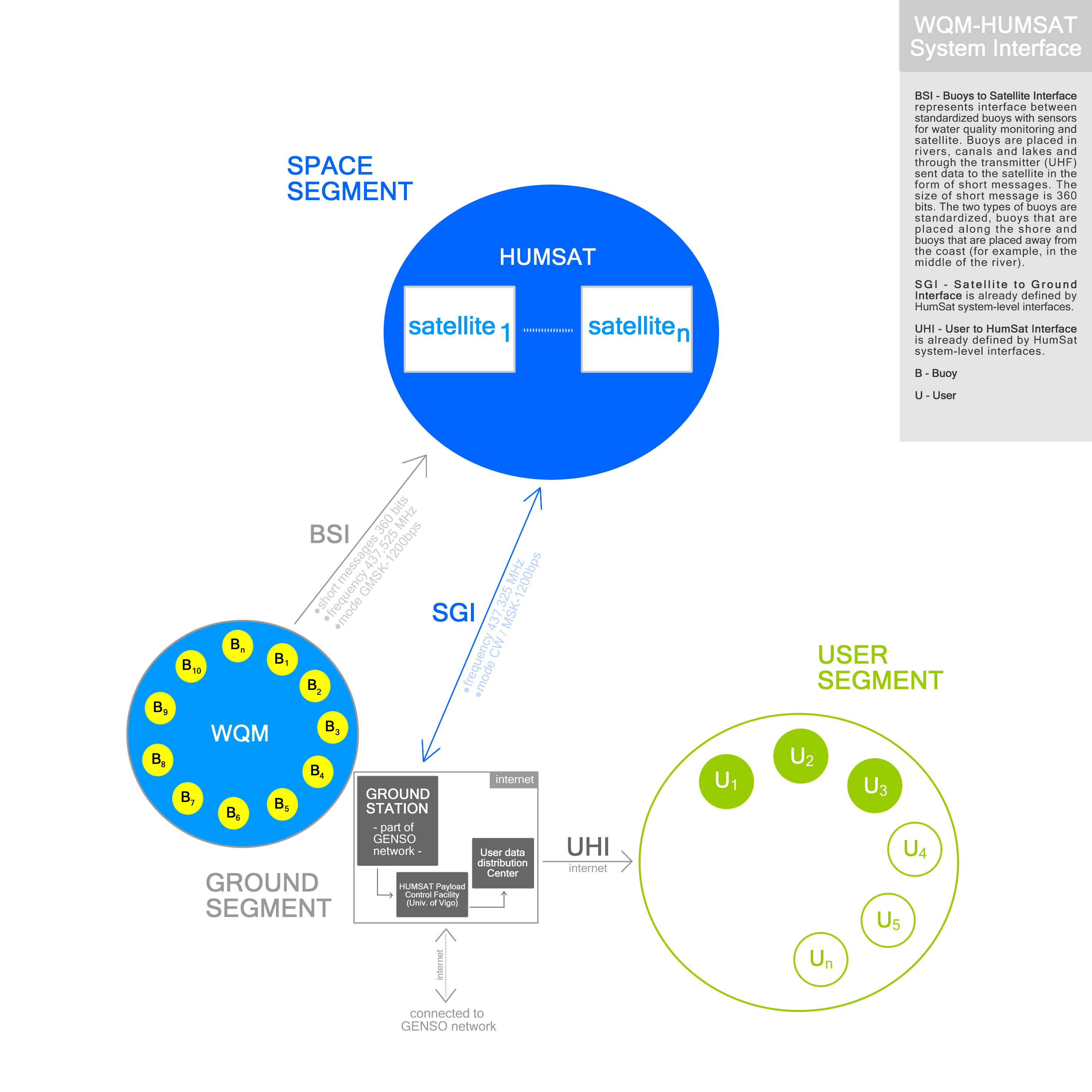
The system for satellite monitoring of surface water quality in real-time comprises four segments:
1. Segment on Earth (in rivers, canals and lakes):
Segment on Earth practically represents the standardized buoys located in rivers, canals and lakes. Each buoy contains electronics (sensors, microcontroller, UHF transmitter, power) required for water quality monitoring. Two types of buoys are standardized as follows: buoys that are placed along the coast and buoys that are placed away from the coast (e.g. the center of the river). Buoys are standardized by the Committee for Space Programme Development in accordance with the prescribed norms for communication with HUMSAT satellites. The data that the sensors are read in rivers, canals and lakes are sent (uplink) to satellites via UHF transmitters during their flyby.
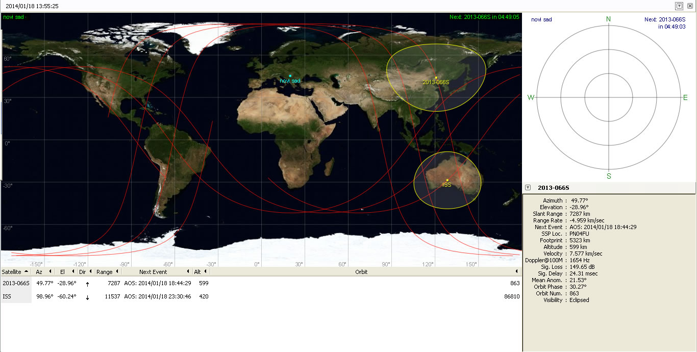
Example of HUMSAT-D satellite:
Frequency for transmit data to satellite is 437.525 MHz (mode-GMSK 1200bps).
2. Segment in Space:
Segment in Spacerepresentthe constellation of HUMSAT satellites that receives data from the Earth (from rivers, canals and lakes), temporarily store them in their own memory and then forward the data to an appropriate ground station during flyby. The satellites are located at an altitude of about 700 km (LEO) and revolving around the Earth at a speed of ~28,000 km / h.
3. Ground station:
The third segment is the ground station of the Committee for Space Programme Development (VHF/UHF, S-band, L-band antenna), which receives the data from the satellites during the flyby (downlink). Ground station work both independently and as part of a global network of ground stations GENSO(http://www.esa.int/Education/How_GENSO_works) in order to receive data from satellites in real time.
Example of HUMSAT-D satellite:
Frequency to receive the data from satellite is 437.325 MHz (mode CW / MSD-1200bps).
4. User segment:
In the Center for decoding, processing and distribution of satellite data, the satellite data which is received by ground stations are decoded and processed into a format that is ‘readable’ and available to all interested users for free. The HUMSAT project is clearly defined that access to data and use of all data in this way obtained for all interested users are free of charge with respect of copyright rules. User’s situation on the field, related to the status of water quality, can monitor via the internet through a PC’s or mobile devices (phone, tablet, etc.) in real time and constantly be in quick notification system. Also, the quick notification system provides and the possibility to inform users via EMERGENCY SMS messages in case of an ‘emergency’, which reduces the possibility that the user is not informed even if it is out of range of the internet. It is foreseen the creation of a user interface with services tailored to user needs, with special attention to the visual identity and user needs in accordance to which type user belongs (citizens, authorities and institutions at the national level/provincial level/local level, educational institutions, farmers, legal persons or organizations).
• WQM-HUMSAT System Interface
• End users of data obtained by the realization of the project and the establishment of system:
- Citizens,
- Authorities and institutions at the national level/provincial level/local level,
- Educational institutions,
- Farmers,
- Legal persons,
- Organizations.